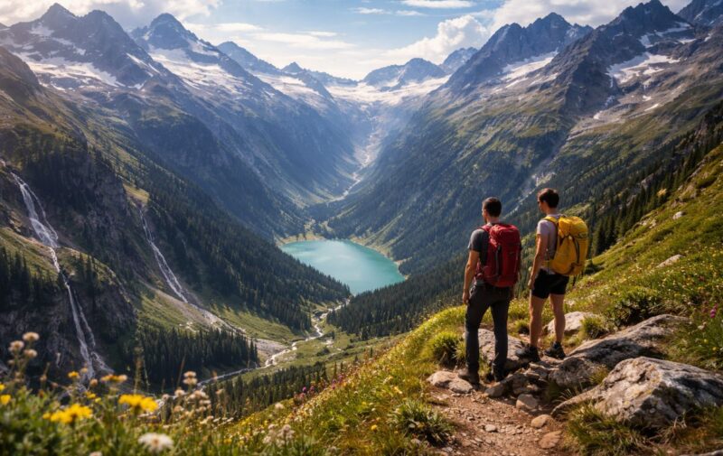
Serious hikers often reach a point where scenic walks stop being enough. Real mountain terrain means sustained elevation gain, rough paths, and weather that changes quickly. Routes demand planning, navigation skills, and the right equipment. Europe offers many hiking regions, but only a few consistently deliver the rugged conditions experienced hikers look for.
This guide focuses on destinations where mountain terrain feels genuine and demanding. Each area offers steep routes, long days on foot, and conditions that reward preparation and experience.
Corfu Interior Mountains – Steep Trails Above the Ionian Coast
Corfu is often associated with beaches, but the island’s interior contains rugged hiking terrain that surprises many experienced hikers. Routes around Mount Pantokrator rise from near sea level to over 900 meters, creating steep climbs within relatively short distances. Rocky mule paths, loose limestone surfaces, and exposed ridges make many trails feel closer to mountain hiking than coastal walking.
Several routes combine sustained elevation gain with limited shade and rough footing. Early starts are important during warmer months, especially from May through September. Hikers should expect long ascents on uneven ground and limited water sources along higher routes.
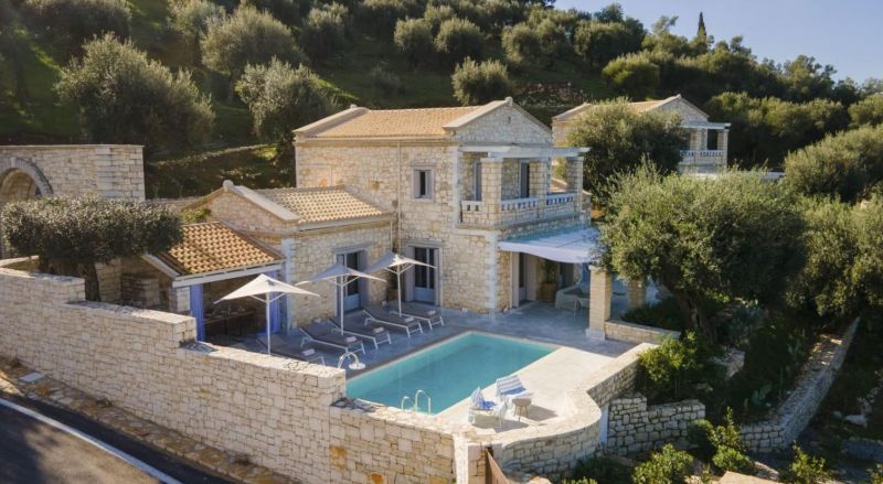
After demanding hiking days, a quiet base helps with recovery and planning the next route. Accommodation options such as ionianstonevillas.com provide a practical location for hikers who want quick access to the island’s mountain trails while still staying close to both coastal and upland routes.
Typical conditions in Corfu’s interior include:
- Steep climbs from low elevations with little gradual ascent
- Rocky limestone paths that can become slippery
- Limited shade on higher ridges
- Heat exposure during summer months
- Narrow village access roads to trailheads
Spring and autumn usually provide the most stable hiking conditions. Cooler temperatures make longer climbs more manageable.
The Alps ─ Long Elevation Gains and High Alpine Terrain
The Alps offer some of the most consistent real mountain terrain in Europe. Routes frequently start around 1,000 meters and climb well above 2,500 meters within a single day. Terrain ranges from forested slopes to exposed ridges and rocky high passes.
Steep ascents define many Alpine routes. Hiking days commonly involve 1,000 to 1,600 meters of elevation gain. Trail markings are usually reliable, but weather can change quickly at higher altitudes.
Typical conditions hikers encounter include:
- Rocky paths with loose stone sections
- Narrow ridgelines with exposure
- Snowfields early in the season
- Afternoon thunderstorms in summer
- Long descents that strain knees
Best hiking months run from late June to early September. Earlier periods often include snow covered routes that require additional equipment and experience.
Navigation remains manageable on marked trails, but fog can make ridge routes challenging.
The Dolomites ─ Steep Limestone Walls and Technical Paths
The Dolomites feel different from the main Alpine ranges. Vertical limestone towers create routes that often involve steep switchbacks and exposed sections. Elevation usually ranges between 1,500 and 3,000 meters.
Trail surfaces include gravel slopes and broken rock. Sections near passes may require hands for balance even on standard hiking routes.
| Characteristic | Typical Conditions |
| Elevation Range | 1,200 to 3,000 m |
| Terrain Type | Limestone and scree |
| Difficulty | Moderate to demanding |
| Best Season | July to September |
The table shows why the Dolomites qualify as real mountain terrain. Steep approaches combine with exposed ridges and sudden weather changes.
Routes often take longer than expected because footing slows progress. Early starts reduce the risk of afternoon storms.
The Pyrenees – Remote Routes and Navigation Challenges
The Pyrenees offer a more remote experience than many Alpine regions. Trails often pass through isolated valleys where hikers may see few people even during peak season.
Elevation usually ranges between 1,000 and 3,000 meters. Many routes include long climbs and extended ridge walking. Weather patterns shift quickly, especially near the French and Spanish border.
Navigation can be demanding due to:
- Sparse trail markings in remote areas
- Multiple intersecting shepherd paths
- Fog near higher ridges
- Long distances between shelters
Alpine terrain refers to environments above the natural tree line where weather exposure increases and vegetation becomes sparse.
The best season runs from July through early September. Snow lingers longer here than many hikers expect.
Strong map reading skills make a significant difference on longer routes.
The Carpathians ─ Wild Terrain and Variable Conditions
The Carpathian Mountains provide a different type of real mountain terrain. Elevations remain lower than the Alps, usually between 1,200 and 2,500 meters, but routes can feel equally demanding due to distance and isolation.
Trail surfaces vary widely. Some sections include muddy forest tracks while others follow rocky ridges above the tree line.
Many hikers underestimate the Carpathians because elevations appear moderate. Physical effort often comes from long distances rather than steep climbs.
Conditions hikers should expect include:
- Sudden weather shifts
- Limited rescue infrastructure
- Long ridge traverses
- Wildlife presence in remote areas
Navigation is usually straightforward on major routes, but smaller paths may be poorly marked.
Preparation matters more than speed in these mountains.
The High Tatras ─ Compact Mountains With Serious Terrain
The High Tatras form the steepest section of the Carpathian range, located along the border of Poland and Slovakia. Despite relatively modest elevations that reach just over 2,600 meters, the terrain feels distinctly alpine. Trails often climb sharply through rocky valleys before reaching exposed passes and ridges.
Many routes involve continuous elevation gain over short horizontal distances. Sections near summits can include chains or fixed supports to help hikers cross steep rock slabs safely. Weather shifts quickly in this compact range, and sudden fog can make navigation difficult above the tree line.
Hikers should expect:
- Elevation ranges between 900 and 2,600 meters, typically
- Steep stone stair sections and rocky trails
- Sudden temperature drops at higher elevations
- Crowded lower trails but quieter high routes
Best hiking conditions usually occur from June through September. Early-season snowfields often remain on shaded slopes longer than expected.
Conclusion
Real mountain terrain requires preparation, endurance, and sound judgment.
The Alps, Dolomites, Pyrenees, and Carpathians each offer demanding routes with different challenges. Choosing the right region depends on experience level, preferred terrain, and available time.
Careful planning and realistic expectations help turn difficult mountain routes into rewarding hiking experiences.